German federated state of Bavaria: characteristics, population, photos, major cities, climate, map and much more
On this page you will find interesting information, statistics about Bavaria: major cities and the capital of the federated state, population, map, climate and weather, flag, coat of arms, photos of sightseeing attractions, ZIP code, phone codes and much more.
§ Brief overview of the Bavaria federated state
Bavaria is Germany’s largest federated state, it is home to the largest mountain in the country, the country's most successful football team, and production of the best German beer. Bavaria is located in the southernmost part of Germany and borders with Austria and the Czech Republic.
The nature of Bavaria is very diverse: there is the Bavarian Forest - part of the forests known as the Bohemian Forest (in German: Böhmerwald), which is the largest forest in Europe. The Alps and the Bavarian Forest are home to rare species of birds and plants; there are many large and beautiful lakes there. Bavaria has many mountains and ancient castles, the most famous of which is Neuschwanstein (in German: Neuschwanstein), the castle of King Ludwig II of Bavaria, built in the 19th century. Millions of tourists come to Bavaria every year, visiting castles, attending national holidays and open festivals, enjoying the nature.
Besides tourism and agriculture, the automotive industry, electrical engineering, chemical industry, and scientific research play an important role in the federated state economy.
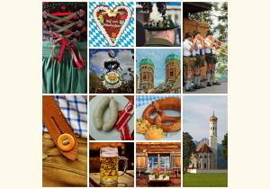
§ Photos of the sightseeing attractions in the Bayern federated state
To enlarge and view the picture, click on it pressing the mouse button.
-

Features of Bavaria
-
The best German beer is made in Bavaria
-
Lake Hintersee in Bavaria
-
Dirndl – a traditional women's costume in Bavaria
-
The Football Club of Bavaria - FC Bayern München e.V.
-
The City of Munich - the capital of Bavaria
-
Neuschwanstein - the most famous castle in Bavaria
-
The ethnic foods of Bavaria - Weisswurst or white sausages, pretzels


§ Population of the Bayern federated state
The population size in Bavaria totals 12'930'751 people. Of these, 6'400'820 are men, which is 49.5 % and 6'529'931 are women or 50.5 % of the whole federated state population. The population density of the Bavaria federated state is 183 people per 1 square kilometer.
Based on the data in Table 1 (see below on the page), the Bavaria federated state occupies 20 % of the entire territory of Germany, which is home to 16 % of the population of the entire country, they live in 2'056 settlements located on the territory of the said land.
§ Climate and weather in Bavaria
Like in other parts of the country, Bavaria has a temperate climate with warm summers and relatively warm winters. According to the German Weather Service (aka the German Meteorological Service) (in German: DWD), in 2023 the average annual temperature in Bavaria was 10.1 degrees Celsius, while in winter the air temperature was on average 1.8 °C, and in summer 18.6 °C. The rainfall in 2023 was 1'045 l/m2, and the sun shone that year in Bavaria for 1'852 hours. Click here for more information about the Climate of Germany
§ Capital of the Bavaria German federated state
The capital of the Bavaria federated state is the City of Munich, in German München or München, Landeshauptstadt, with a population of more than 1'513'000 people.
§ Statistics, essential data about the federated state
Table 1 below presents statistics as to the data for the federated state of Bavaria, as well as indicators for the whole of Germany for comparison. Besides, from Table 1, you will learn the percentage ratio of the indicator for the federated state to the indicator for the whole of Germany.
Table 1. Statistical data on the Bayern federated state as of early 2017.
| Descriptor | Value as to the federated state and its percentage ratio to the indicator for the whole of Germany | Value for the whole of Germany | |
|---|---|---|---|
| Name in German | Bayern | - | - |
| Federated state type designation, in German | Freistaat | - | - |
| Abbreviation (code) of the federated state, in German | BY | - | - |
| Capital of the federated state | Munich (нем. München) | - | - |
| Territory, land area | 70'542 km2 | 20 % | 357'578 km2 |
| The federated state population, all people altogether | 12'930'751 | 16 % | 82'521'653 |
| The federated state population, men | 6'400'820 | 16 % | 40'697'118 |
| The federated state population, women | 6'529'931 | 16 % | 41'824'535 |
| Population density, people per km2 | 183 | 79 % | 231 |
| Number of administrative districts (in Ger .: Bezirk) | 7 | 37 % | 19 |
| Number of counties (in Ger.: Kreis) | 96 | 24 % | 401 |
| Number of cities of regional subordinance, i.e. district-free cities or urban districts (in Ger.: kreisfreie Städte) | 25 | 23 % | 107 |
| Number of the federated state rural districts (in Ger.: Landkreis) | 71 | 24 % | 294 |
| Number of municipalities (in Ger.: Gemeinde), i.e. localities or settlements | 2'056 | 19 % | 11'042 |
| Number of cities | 317 | 15 % | 2060 |
§ The Bavaria federated state holidays schedule
Every federated state in Germany has the right to establish holidays, days off from work, which are valid on their territory. On the territory of Bavaria there are 16 official holidays. A detailed calendar of the Bavaria federated state public holidays can be found on a dedicated page of our website. The school vacations schedule of the Bavaria federated state is also established by a decision of the local government distinct from other German federated states.
§ Major cities in the Bavaria federated state
In the Bayern federated state there are 2'056 settlements, of which 317 are cities. Table 2 below contains a list of major, large cities in the said federated state.
Table 2. Major cities in the Bavaria federated state in English and German.
| Nr. | Name of the city | Name of the city in German | Population size, rounded to thousand people |
|---|---|---|---|
| 1 | Munich (Capital of the federated state) | München | 1'513'000 |
| 2 | Nuremberg | Nürnberg | 524'000 |
| 3 | Augsburg | Augsburg | 302'000 |
| 4 | Regensburg | Regensburg | 158'000 |
| 5 | Ingolstadt | Ingolstadt | 142'000 |
| 6 | Fürth | Fürth | 132'000 |
| 7 | Würzburg | Würzburg | 128'000 |
| 8 | Erlangen | Erlangen | 117'000 |
| 9 | Bamberg | Bamberg | 80'000 |
| 10 | Landshut | Landshut | 76'000 |
| 11 | Bayreuth | Bayreuth | 75'000 |
| 12 | Aschaffenburg | Aschaffenburg | 73'000 |
| 13 | Kempten | Kempten (Allgäu) | 71'000 |
| 14 | Rosenheim | Rosenheim | 65'000 |
| 15 | Neu-Ulm | Neu-Ulm | 62'000 |
| 16 | Schweinfurt | Schweinfurt | 55'000 |
| 17 | Passau | Passau | 54'000 |
| 18 | Freising | Freising | 50'000 |
| 19 | Straubing | Straubing | 50'000 |
| 20 | Dachau | Dachau | 49'000 |
| 21 | Vöhringen | Vöhringen | 14'000 |
| 22 | Grafenwöhr | Grafenwöhr | 7'000 |
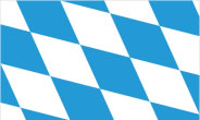
§ Flag and coat of arms of the Bayern federated state
In the picture below, you can see the flag or flag / coat of arms of the federated state.
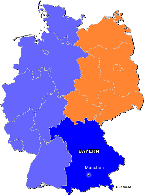
§ Bavaria on a map of Germany
In the picture below, you can see the location of the federated state and its capital on a map of Germany. Map of all the federated states of Germany and their capitals.
- Information about Germany
- All about Germany and the Germans - a general description of the country
- Administrative and territorial structure of Germany
- National symbols of Germany: flag, coat of arms, anthem, buildings, mottos and others
- Federated states of Germany and their capitals in German and English
- Political structure of Germany: parties, elections, authorities, policy
- Germany budget: structure, revenues and expenditures
- Climate and weather in Germany
- List of all German cities ordered alphabetically in English and German