List and map of the federated states(lands) of Germany with their capitals in German and English, brief information about the federated states of West and East Germany
- Information on the page:
- Federated states of Germany
- List of the lands in Germany
- The capital cities of the German federated states
- Map of the federated states and their capitals
- Lands of West Germany
- Lands of East Germany
- Area of the federated states
- Population by federated state
- Comments and questions
§ Information about the federated states of Germany
The country of Germany is a Federal Republic, which means that it includes regions or lands that have political independence or great freedom in domestic policies, remaining, however, within the political and legal borders and within the state or Federation itself.
Why are German regions or federated states called Länder?
The name "Land" (in German: Land) in itself has the meaning of "country" or "land" and this causes misunderstanding, since both the world’s sovereign states and politically independent territories of a country are called by the same word. However, in the context of a country's territory, "Land" (in German: Land) means a province or a state, as is customary in the United States. The Germans themselves, in everyday speech, use the expression "federated state" (in German: Bundesland) to denote the Länder of Germany, so that it is clear what they are talking about.
How many federated states are there in Germany?
In Germany, in total, there are 16 federated states, i.e. 16 federal subjects, of which 3 are referenced as "free states" (in German: Freistaat) and other 3 are free cities that are at the same time federated states (with the exception of Bremen, which also includes the city of Bremerhaven). Despite such historically established designations, all the 16 subjects of the federation have the same rights.
§ List of the German federated states in English and German
Table 1 below contains the names of the federated states in English and German, as well as their abbreviated designations recognized in Germany.
Table 1. List of the German federated states.
| Abbreviation | Name in German | Name in English | Designation of the federated state |
|---|---|---|---|
| BW | Baden-Württemberg | Baden-Württemberg | Land |
| BY | Bayern | Bavaria | Freistaat |
| BE | Berlin | Berlin | Land |
| BB | Brandenburg | Brandenburg | Land |
| HB | Bremen | Bremen | Freie Hansestadt |
| HH | Hamburg | Hamburg | Freie Hansestadt |
| HE | Hessen | Hesse | Land |
| MV | Mecklenburg-Vorpommern | Mecklenburg-Vorpommern | Land |
| NI | Niedersachsen | Lower Saxony | Land |
| NW | Nordrhein-Westfalen | North Rhine-Westphalia | Land |
| RP | Rheinland-Pfalz | Rhineland-Palatinate | Land |
| SL | Saarland | Saarland | Land |
| SN | Sachsen | Saxony | Freistaat |
| ST | Sachsen-Anhalt | Saxony-Anhalt | Land |
| SH | Schleswig-Holstein | Schleswig-Holstein | Land |
| TH | Thüringen | Thuringia | Freistaat |
The designations of the German Länder are historically established names of the federated states that currently do not give them any special advantages over other federated states:
- Land - region, county or federated state (conventional designation);
- Freistaat - free state;
- Freie Stadt - free city;
- Hansestadt - a Hanseatic city (formerly a member of the Hanseatic League of market towns, usually being ports at the same time).
§ The capital cities of the German federated states in English and German
Table 2 below provides a list of the federated states and their capitals in English and German.
Table 2. The federated states of Germany and their capitals.
| Federated state | Name of the capital in German | Name of the capital in English |
|---|---|---|
| Baden-Württemberg Baden-Württemberg | Stuttgart | Stuttgart |
| Bayern Bavaria | München | Munich |
| Berlin Berlin | Berlin | Berlin |
| Brandenburg Brandenburg | Potsdam | Potsdam |
| Bremen Bremen | Bremen | Bremen |
| Hamburg Hamburg | Hamburg | Hamburg |
| Hessen Hesse | Wiesbaden | Wiesbaden |
| Mecklenburg-Vorpommern Mecklenburg-Vorpommern | Schwerin | Schwerin |
| Niedersachsen Lower Saxony | Hannover | Hanover |
| Nordrhein-Westfalen North Rhine-Westphalia | Düsseldorf | Düsseldorf |
| Rheinland-Pfalz Rhineland-Palatinate | Mainz | Mainz |
| Saarland Saarland | Saarbrücken | Saarbrücken |
| Sachsen Saxony | Dresden | Dresden |
| Sachsen-Anhalt Saxony-Anhalt | Magdeburg | Magdeburg |
| Schleswig-Holstein Schleswig-Holstein | Kiel | Kiel |
| Thüringen Thuringia | Erfurt | Erfurt |
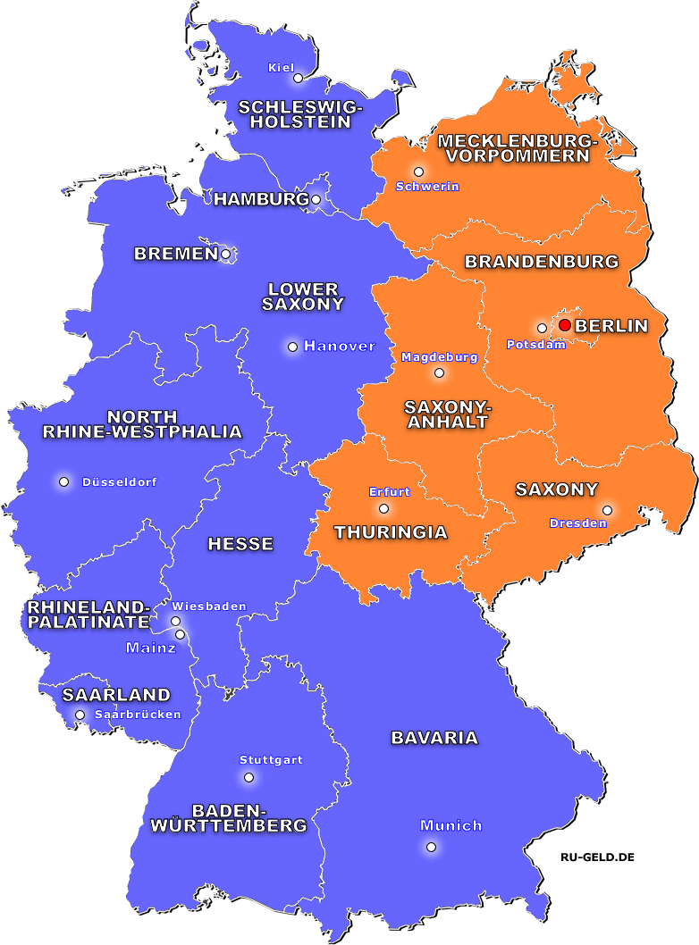
§ Maps of the Länder or federated states of Germany and their capitals in English and German
Further on the page you will find the maps of Germany with the federated states highlighted there, as well as their capitals in German and in English. To zoom in on a map, click on it. The Länder of the western part of the country are highlighted in blue, and those of the eastern part are shown in orange.
Figure 1. Map of the federated states of Germany with their capitals, in German

Figure 2. Map of the federated states of Germany with their capitals, in English
§ Federated states of West Germany (the German Federal Republic)
After the Second World War and until 1990, when the reunification of Germany took place, the eastern part was separated from the Federal Republic of Germany. There were 11 federated states on the territory of Germany. Although at present all the federated states of both western and eastern parts have the same status, yet, the standard of living, human relations and the environment are different in these parts of the country. It should also be noted that Berlin, as a city and a federated state, used to be divided into West Berlin and East Berlin, for this reason we attribute it both to the western and eastern parts of Germany. Further, we list the federated states of the western part of Germany.
- Baden-Württemberg
- Bavaria
- Berlin
- Bremen
- Hamburg
- Hesse
- Lower Saxony
- North Rhine-Westphalia
- Rhineland-Palatinate
- Saarland
- Schleswig-Holstein
§ Federated states of the eastern part of Germany (formerly the German Democratic Republic or East Germany)
Next, we offer a list of the federated states of the eastern part of the country (a total of 5), formerly the GDR. Berlin, as a city and a federated state, used to be divided into West Berlin and East Berlin, for this reason we attribute it both to the western and eastern parts of Germany.
- Berlin
- Brandenburg
- Mecklenburg-Vorpommern
- Saxony
- Saxony-Anhalt
- Thuringia
§ Table and diagram of the German federated states area
Table 3 below features a list of the German federated states, sorted into the descending order from the federated state with the largest area in the country to the smallest one in terms of its area.
Table 3. The federated states of Germany and the area they occupy.
| Federated state | Occupied area in km2 | |
|---|---|---|
| BY | Bayern , Bavaria | 70'542.00 км2 |
| NI | Niedersachsen , Lower Saxony | 47'709.80 км2 |
| BW | Baden-Württemberg , Baden-Württemberg | 35'748.30 км2 |
| NW | Nordrhein-Westfalen , North Rhine-Westphalia | 34'112.70 км2 |
| BB | Brandenburg , Brandenburg | 29'654.40 км2 |
| MV | Mecklenburg-Vorpommern , Mecklenburg-Vorpommern | 23'293.70 км2 |
| HE | Hessen , Hesse | 21'115.00 км2 |
| ST | Sachsen-Anhalt , Saxony-Anhalt | 20'452.10 км2 |
| RP | Rheinland-Pfalz , Rhineland-Palatinate | 19'858.00 км2 |
| SN | Sachsen , Saxony | 18'450.00 км2 |
| TH | Thüringen , Thuringia | 16'202.40 км2 |
| SH | Schleswig-Holstein , Schleswig-Holstein | 15'802.30 км2 |
| SL | Saarland , Saarland | 2'571.11 км2 |
| BE | Berlin , Berlin | 891.12 км2 |
| HH | Hamburg , Hamburg | 755.30 км2 |
| HB | Bremen , Bremen | 419.84 км2 |
| Total land area of West Germany (excluding Berlin) | 248'634.4 km2 | |
| Total land area of East Germany (including Berlin) | 108'943.7 km2 | |
Diagram 1 presents a comparison of the federated states in terms of the area they occupy. The size of the area is expressed in thousands of square kilometers. The West Germany federated states are marked in purple, while those of East Germany are shown in orange.
Diagram 1. Land area of Germany
Germany's largest federated state
As can be seen from the table and diagram above, the largest federated state in Germany is Bavaria, which has an area of more than 70 thousand square kilometers.
Bavaria is the largest federated state in Germany with an area of more than 70 thousand km2
Germany's smallest federated state
As can be seen from the table and diagram above, , the smallest federated state in Germany is Bremen, which has an area of 0,42 thousand square kilometers.
Bremen is Germany's smallest federated state with an area of 0,42 thousand km2
§ Table and diagram of the German population by federated state
Table 4 below features a list of the German federated states, sorted into the descending order from the federated state with the largest population size in the country to the smallest one in terms of its population size.
Table 4. The federated states of Germany and the population size as of early 2017.
| Federated state | Population size, mln. | Population density per 1 km2 | |
|---|---|---|---|
| NW | Nordrhein-Westfalen , North Rhine-Westphalia | 17.9 | 524 |
| BY | Bayern , Bavaria | 12.9 | 183 |
| BW | Baden-Württemberg , Baden-Württemberg | 11.0 | 306 |
| NI | Niedersachsen , Lower Saxony | 7.9 | 167 |
| HE | Hessen , Hesse | 6.2 | 294 |
| SN | Sachsen , Saxony | 4.1 | 221 |
| RP | Rheinland-Pfalz , Rhineland-Palatinate | 4.1 | 205 |
| BE | Berlin , Berlin | 3.6 | 4012 |
| SH | Schleswig-Holstein , Schleswig-Holstein | 2.9 | 182 |
| BB | Brandenburg , Brandenburg | 2.5 | 84 |
| ST | Sachsen-Anhalt , Saxony-Anhalt | 2.2 | 109 |
| TH | Thüringen , Thuringia | 2.2 | 133 |
| HH | Hamburg , Hamburg | 1.8 | 2397 |
| MV | Mecklenburg-Vorpommern , Mecklenburg-Vorpommern | 1.6 | 69 |
| SL | Saarland , Saarland | 1.0 | 388 |
| HB | Bremen , Bremen | 0.7 | 1617 |
| Total population of West Germany (excluding Berlin) | 66.4 | - | |
| Total population of East Germany (including Berlin) | 16.2 | - | |
Diagram 2 presents a comparison of the federated states in terms of the population living in them. The population size is expressed in millions of people. The West Germany federated states are marked in purple, while those of East Germany are shown in orange.
Diagram 2. Population size of Germany’s federated states
The largest population size in the federated states
As can be seen from the table and diagram above, the largest population size in Germany is in the federated state of North Rhine-Westphalia; it exceeds 17 million people.
However, the most populous federated state in Germany is Berlin, with more than 4012 peopl per 1 square kilometer.
North Rhine-Westphalia has the largest population in Germany, totalling 17 million people
Berlin is the most densely populated federated state in Germany, with 4012 people per 1 km2
The smallest population size in the federated states
As can be seen from the table and diagram above, the smallest population size in Germany is in the federated state of Bremen it makes 0,68 million people.
However, the most sparsely populated federated state in Germany is Mecklenburg-Vorpommern, with only 69 people per 1 square kilometer.
Bremen has the smallest population size in Germany, with 0,68 million people
Mecklenburg-Vorpommern is the most sparsely populated federated state in Germany, with 69 people per 1 km2
- Information about Germany
- All about Germany and the Germans - a general description of the country
- Administrative and territorial structure of Germany
- National symbols of Germany: flag, coat of arms, anthem, buildings, mottos and others
- Federated states of Germany and their capitals in German and English
- Political structure of Germany: parties, elections, authorities, policy
- Germany budget: structure, revenues and expenditures
- Climate and weather in Germany
- List of all German cities ordered alphabetically in English and German